Florida Senate Bill 212 – (2023)
Outdated mapping data significantly diminishes its value. The accuracy and utility of maps heavily depend on having up-to-date information. This becomes particularly crucial during emergencies, such as an active shooter situation at a school, where first responders must quickly locate, plan routes, and coordinate rescue efforts effectively. Our interactive mapping service is designed to provide the best user experience, offering real-time and precise information to navigate emergencies with efficiency.
Ignite Your Potential for Heightened School Security
Florida Senate Bill 212 (2023) – Emergency Response Mapping
The importance of offering mapping data to first responders and key personnel during emergencies has become a prominent topic of discussion. In Florida, Senate Bill 212 (2023) mandates that all public schools must provide emergency response mapping data to first responders. However, the question arises whether a static map is the optimal solution available. Although a basic floor plan can provide some essential information, it might not offer enough situational awareness for first responders. This is where 911inform steps in with an interactive mapping experience that equips everyone involved with the necessary tools to direct, make informed decisions, and ensure the safety of all individuals during emergencies.
Although the bill is currently law in Florida, our system can provide schools across the country with the tools to effectively manage an emergency situation, and also prepare a school district to meet compliance standards in circumstances where similar legislation may soon be passed.

Current mapping data becomes evident in scenarios where quick and precise decision-making is essential to ensure the safety and well-being of your staff and students. In an emergency, having real-time and accurate mapping data can significantly aid first responders in such capacities as Quick Location Identification, Route Planning, Resource Coordination, Situational Assessment, and Communication.
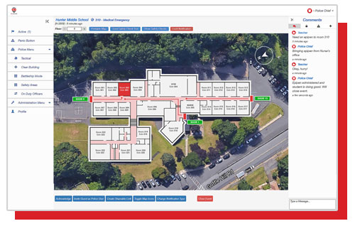
Discover our revolutionary tool that puts the power of real-time emergency information at your fingertips. With 911inform's interactive mapping, you can now take charge of your school district’s safety like never before. Access all your buildings’ security controls all in one place, developing a single pane of glass emergency solution.
Interactive Mapping Features:
- 5 Years of Mapping Updates
- Standard Emergency Mapping Data and Imagery for All School Buildings
- Digital Format Provided Directly to First Responders
- Compatible and integrated with common software and security platforms used by local, state, and federal agencies and with software and security platforms used by schools
- Printable maps
- Compiled through individual walk-throughs of the premises and verified for accuracy
- Oriented true north
- Overlaid on current aerial imagery
- Overlaid on x/y coordinates
- Site-specific labeling
- Rapid Mass Notifications
- Route to Nearest Door
- Common Messaging Platform
- Drill Mode
- Battleship Mode
- Tactical Images
- Clear Room Mode
- Room Information:
- Name
- Listed Extensions
- 360° Room Image
- Registered, Checked In, and Missing Students
- Escape Route to Nearest Exit
- Panic Buttons to Set Emergency Notification Types:
- Active Shooter
- Bomb Threat
- Lock Down
- Medical Emergency
- Shelter in Place
- Silent Alarm
- Emergency
- 911 Phone Call
- Upset Parent
- Mental Health Crisis
- Fight
- Choice of icons to include on map, including ESRI icons:
- Locatable AEDs & Chemicals
- Camera Locations
- Doors
- Fire Extinguishers
- Alarms
- Hazardous Materials
- Shutoff Valves
- Speakers
- Safe Zones
- Nurse’s Office
- SRO Contact Information
Enhanced Options & Integrations
Vape Detection
Weapon & Gunshot Detection
Facial Recognition
License Plate Reading
License Plate Environmental Detection & Monitoring
The No. 1 Safety Solution for Interactive Mapping
911inform’s user-friendly software, integrated platform, and connected building controls represent a significant leap forward in campus safety and emergency management. By leveraging intelligent technology and connectivity, this innovative solution empowers school districts to enhance their emergency response capabilities, ensuring the well-being of students, staff, and visitors.
Don’t wait for the unexpected to happen…
take the lead in ensuring a safer tomorrow.
Join the ranks of over 5,000 buildings across the nation who are making a difference with 911inform!